
On 23rd January, we hadn’t ridden very far north from Mallacoota when we crossed from Victoria into New South Wales.

Louise had performed yet another stunning job of sleuthing that led us to Mystery Bay and the bush camp site in the trees behind beautiful beaches. But I’ve hopped ahead too far. We passed through Bermagui and while Louise conferred with a lady in the info centre, I inspected a promising little bakery across the road. The baguettes looked just like those pointy
 -ended ones (top right in photo below) you find in French pattiseries. Once set up at the Mystery Bay camp site, we ripped into one with butter and camembert. The bread was the best we’ve had all trip. Such simple pleasures can be so exquisite.
Mystery Bay was bracketed by rocky headlands and provided a popular arena for families to enjoy sheltered ‘beach time’. Beyond the southern mini-headland was another beach with another beyond it. We less social animals, preferred the tranquillity of the deserted beach a few down. It was beautifully unspoiled. Two days here allowed for a bit of internet time back in Bermagui and thus another baguette.
There was a certain urgency to leave Mystery Bay on 25th January – we had a table booked for lunch at Rick Stein’s “Bannisters Restaurant” for lunch in Mollymook. The sunshine in Mystery Bay was valued as we rode north to Mollymook getting wetter by the kilometer. Due to school holidays we had booked a tent site but on arrival, upgraded to a cabin. The lunch was magnificent – it needed to be to offer a hint of value with the Rick Stein name adding about ten bucks per course. After a bit of time in frugal mode, we pushed the boat out, exploring the wine list by the glass and then, on departure, the
 top shelf. The fella who poured my Calvodos didn’t know what it was and half-filled a wine glass. Back in the cabin it was water and tea to sober up with the Aussie Tennis Open keeping us entertained.
The following morning we set off on a big ride north and then inland, skirting around Sydney and up into the Blue Mountains. As luck would have it, the lunchtime munchies arrived at the same time as an old-fashioned roadside Inn hoved into view. It turned out to be “Peppercorn Creek”, an organic café operated by a Christian community. The Beef Stroganoff pie rated an 8. Louise’s Chicken and Leek pie an 8+. Our destination was Mega Valley’, left from Blackheath. The black clouds had been gathering so with a murderous sky above, we checked into a motel in Blackheath, minutes before the heavens opened. That evening we watched Fed put on a masterclass against the up-and-coming Korean chap, Chung.
Saturday 27th we set  off towards Mudgee visiting Mount Panarama at Bathurst on the way.
Being a circuit of public roads, we did a couple of laps and were struck by the steepness of the hill and the tightness of the turns leading down from it.
Our actual destination was Hill End, in the sticks between Bathurst and Mudgee. Again, the black clouds were gathering. Brief consideration was given to sheltering in a tiny church but clad in our notionally waterproof giant condoms, we continued along a great up and down riding road. Then the lightning bolts were followed instantly by thunder claps, the prompt the rain was waiting for. And down it came. An utter deluge. It fell so heavily the parched fields were soon bedecked with water rushing down them. Big roadside ditches overflowed, torrents crossed the road and elsewhere it seemed to be an inch deep in seething water. Our visors were streaming so we plodded along in second gear over this wild hill-billy country and then, as suddenly as it started, it stopped.  We rode into the little camp site at Hill End sodden. Once this place had a high street a mile long and 26 pubs. Now the local council is trying to preserve the 20 or so buildings that remain from those gold rush days. One pub still functions – as above. On the Sunday morning (28th) we left, we did a big walk up to Bald Hill thinking it was Merlins Lookout. Then rode the short distance up to the pub where we crossed the road to the
 little bakery café. The Irish Lamb Pie was a 9+. Replete with pie int’ tum, we headed north along more hill-billy roads through another cloudburst, this one of longer duration that folded a big gum tree onto the road ahead of us. We slowed to a halt to find the driver of the 1st ute to the scene man-handling a sizeable section of tree to the side of the road. I joined the effort and hauled another smaller section and was impressed to find that it was a she – they make ‘em burly round there. In minutes other utes had arrived and the tree was soon losing the battle. As we rode around the prostrate and shrinking tree, the intact trunk that blocked one lane was being winched out of the way. We reached our Telegraph House apartment at Gulgong, saturated. But the weather, like us, changed so that our gear swung gently in the warm evening breeze and sunshine. We stayed 3 nights, not because Gulgong offered much, although in Gold Rush days there were 20,000 souls living there instead of the mere 2,000 now. The purpose was to allow me to focus Monday 29th and Tuesday 30th January upon the logistics to get our bikes and ourselves back to NZ 18 days later. We also had the opportunity to watch the Men’s Final which saw Fed beat Cilic in a thrilling 5-setter. Feeling chuffed with the organisational progress by the morning of 31st, we headed NE from Gulgong for Gloucester………
 which didn’t inspire us so we decided to continue on to the next night’s destination of Port Macquarie. This involved a section of road known as “Buckett’s Way” – above. Motorbike riders prefer to avoid main highways. We took the road east towards the A1 Highway but turned north at Kranbach. From there we passed through Burrell Creek, Wingham, Killabakh, to Comboyne. This last section was challenging. The weather had deteriorated to light rain and then without warning, the tarmac finished and the unsealed road starting snaking its way up and up and up through thick forest until we were high on a ridge. The road then carried on up with daunting drops to left and then right but the view of the forested drop was mercifully obscured by rain and mist – we were actually in the cloud. Eventually we headed downhill with the total 40 km journey over this immense chunk of the Great Dividing Range taking 1 hour to complete. Back down on more level land tarmac greeted us. Finally, after about 530 kms and 6 or 7 hours riding, we checked into Beachside Apartments opposite Flynn’s Beach in Port Macquarie.
  Camping was not an option yet again. But Mike’s Seafood was and a great feed of fish and chips hit the spot.
Foul weather extended our stay in Port Macquarie, allowing time for my rear tyre to be replaced. One afternoon while Louise had a nap, I had a beach walk and a spot of rigorous body-surfing at Flynn’s Beach – above – where only the very keen were in the water. We walked round to the Koala Hospital and learned what a dedicated bunch of mostly volunteers can achieve for these furry friends. Louise has written a piece about this wonderful operation. All I might add here is that the happy chappie in the photo above strikes a pose that puts me in mind of how I feel on the bike – clinging on and lovin’ it!
Burkhardt’s Bakery was highly rated but I couldn’t give its Steak and Mushroom Pie more than a 7.
The forecast suggested better weather lay inland so on 3rd February we rode out of Port Macquarie along the Oxley Highway to Walcha. What a ride. From Walcha up Thunderbolt’s Way to Bundarra and a free camp by the river – see below. About 37 kms south from there along dirt roads was Rockview, a property bought by Simon Marais for the South Endeavour Trust – see piece about this further on.
Back for a pub lunch in Bundarra and a puncture for Louise – again. We figured we would need to take the wheel off, strap it to my bike and then, the following day, Monday, I would take it up to Inverell to get it fixed. When checking with the publican if we could leave the bike round the back overnight, a local sitting at the bar said “Hang on a minute.” He peered out of the front door and showed us the sight of a building nearly opposite where the garage door was open. “He’ll fix it.” There must be a moral to this story.
Bundarra up to Tenterfield on Monday where we noticed a sign advertising Bed and Breakfast for $99 in a mansion – Stannum House. For those who have seen The Best Exotic Marigold Hotel, this film might give a few clues as to the style of the place and the Sri Lankan family that owned and operated it. Magnificent in its bones, but somewhat tacky in its fixtures and fittings,
 I had a go at the $10 buffet dinner, tempted by the reference to two Sri Lankan dishes. I returned upstairs to my hunger-free wife and described the repast as being akin to a school lunch. However, we stayed another night to facilitate a ride to Bezzants Lease,
 another South Endeavour Trust property. That night we enjoyed a smoked salmon salad on the roof ‘look-out platform’ and washed it down with a bottle of bubbles.
Wednesday 7 February saw us go north from Tenterfield on a big loop ride through beautiful country, passing through Bald Rock National Park, where we walked a short distance to Thunderbolt’s Hideout,
 Captain Thunderbolt aka Frederick Wordsworth Ward being a reknown bushranger (1835 to 1870).
The loop ride took us past Wylie Creek, Woodenbong, Kyogle and onto Lismore, treating us to some lengthy spells of good quality unsealed road and some shorter sections of the worst sealed road we had encountered. That night we stayed with friends, Ross and Belinda in Evans Head and a very social night it was too.
On Thursday another soft front tyre on Louise’s bike trimmed our plans of another loop ride, instead getting a new inner tube fitted in Ballina. From there to Skennars Head for a night catching up with Heika and Winston. We dined at The Red Wok Thai Restaurant in Ballina, where the food was like the evening – excellent.
Finally, we rode into Byron Bay on Friday 9 February, checked into The Oasis Apartments for 3 nights spanning a very special occasion. Many months previously, young friends Kristian and Anja had invited us to their Wedding Party on 10 February in Byron Bay. We decided to make this the ‘finishing’ point for our Big Aussie Trip. Sam and Val came across for the weekend, having befriended the happy couple during their year in Wellington. This made for a double treat for us, welcoming Sam and Val to the apartment having not seen them since April 2017.
On the Saturday we walked into town then along the famous Byron Bay Beach towards the lighthouse. Then up onto the headland and along the track to the most easterly point of Australia – photo right.
Not much further in distance but what felt like a lot in altitude was the lighthouse – a real beauty.
Since most people reading this will not know the couple, I’ll skip the details of the wedding. Suffice it to say that this very special pair of individuals were at the centre of a bunch of wonderful people gathered to celebrate their tying of the knot. A beach was involved. A Bistro. A superb meal. Lots of entertaining speeches. Some boogie, with Eagle Rock necessitating a down trou dance for the chaps – strange but fun. A brunch aftermath the next morning and then everyone scattered. We had some beach time back near our apartment, followed by a hit of tennis then a swim. Sam and Val headed off for a skiing holiday in Japan on Sunday evening, leaving us to prepare for the last dash south towards Sydney the next morning.
On Monday 12 February we left Byron Bay and blasted 526 kms down the Pacific Highway to Bulahdelah, about 240 kms north of Sydney. The objective for Tuesday was to return to Jean and Cathy’s house by 11 am, the 18 May 2017 starting point for the trip. Rather appropriately for a big loop ride around Australia, they live in Boomerang Street.
The South Endeavour Trust
Back in the early 2000s Jean introduced me to his friend, Simon Marais, who had established Allan Gray Australia, an investment management firm with links to Orbis. I met Jean after he spear-headed the establishment of the Orbis Sydney office in 2002, Orbis being a specialist global equities management firm. These encounters were part and parcel of my advisory firm’s commitment to investment management research.
Back to Simon, he impressed as an unusually discerning stockpicker with courageous commitment to investing against the sway of the herd. I had the great privilege of getting to know this giant of a human being, giant in both the physical and intellectual sense. A year or two before his tragically early death in February 2015, Simon made mention of a bit of land he’d bought in the Far North of Queensland that had a few cattle on it. It was only following his death that I learned that this was yet another example of Simon’s modesty and tendency towards understatement – the Kings Plains property he was referring to was 68,000 hectares and turned out to be just one of several properties he bought as he created the South Endeavour Trust (www.southendeavour.com.au), a definitive demonstration of his massive commitment to conservation. This web site is well worth studying as a monument to one man’s determination to make a difference.


On the left is the photo that identifies Rockview by showing the cause of its name. But on the right is Rockview itself but it could be anywhere from this shot!!!
We drove past the entrance to the Kings Plains property on our way to Cooktown back in June 2017. Our intention had been to take some footage on a Go Pro we bought for that purpose but alas, our visit was discouraged at that particular time. However, just


recently, as we weaved our way up through northern NSW, we made a point of roaming off along some knarly bush roads to visit Rockveiw and Bezzants Lease. The photos included here are probably of bits of those properties, Rockview being more certain due to the view but neither sporting signage as they, like the other properties, are the preserve of the flora and fauna that made their acquisition important. Above left the sign shows the way. On the right, we reached a point we thought the property may have started ……….. so that might be part of it in the distance. This particular one acts as a  bridge between a reserve and a National Park so that endangered species can move across the sum of the parts. In the photo on the left I am seeking to get past a rather large item of fauna that acted as a security guard for the property – Louise has more to say on this encounter.
The Bikie Boomerangs Return
For our whole trip we were keen to be rural, minimizing time in cities. We made an exception for Adelaide but avoided Melbourne and by-passed Sydney when travelling north to Byron Bay. But Tuesday 13th February was our last day on the bikes in Australia’s great outdoors, and one that saw us enter Sydney’s north and return to where it all started, in Turramurra.


On the left was us leaving with Mick as our guide out of Sydney. On the right, we’ve just returned, nine months later.
From Jean and Cathy’s we rode the short distance to ProCycles in Hornsby where the purging of fuel and disconnecting of the batteries was certified, the bikes cleaned and then delivered on Wednesday to Jean’s studio for crating up.


Our Big Aussie Trip was over. The total distance travelled was 24,233 on motorbikes plus about 2,000 kms up and down Cape York in the Land Rover. The replacement motorbike I bought in Cairns in July 2017 had 27,530 kms on the clock when we set off west from Cairns. Below shows a reading of 48,663 in Sydney, seven months later.

There will be one last post for this trip – a sort of epilogue-blog. It will share a few unbiased observations about Aussie, the results of the pie survey, a note of ‘favourites’, and maybe other random reflections.


 Hargreaves Hill beers. The ESB caught my eye then tipped from a glass and sent the palate into raptures. ESB stands for Extra Special Bitter, an English classic whose acronym is often associated with Fullers brewery in Chiswick, London. The benchmark to beat if you like. Which I do and Hargreaves Hill ESB nearly did. In previous blogs I have lamented the lack of decent beer in Australia, with 95% of what Aussies call beer being closer to industrial effluent, cooled, gaseated and pump-primed by marketing gurus to make the stuff sell. Of all the micro-brewery beers I have tried on this lengthy lap, Hargreaves Hill ESB takes line honours.
 so that was our pick. However, the prospect of drinking awful beer to see in the New Year bade as badly for the year ahead as it did for my taste buds. I nipped into the RSL in the afternoon – see above photo – and arranged to deposit ample supplies of Hargreaves Hill ESB behind the bar, with a chunk of ‘corkage’ easing the way. We had a great night, meeting all sorts of people and experiencing little competition for the dance floor in spite of the DJ’s inspiring efforts. The mode of transport shown in the photo turned out to be unrepresentative of the age group there on the night. Sadly it wasn’t there when we set off to walk home.


 good beer, cider and a reasonable drop of 2012 Yarra Valley Pinot Noir. Our stay did facilitate some treatment of the goats where extra hands may have been useful. But goats are goats, always non-compliant and Louise’s latest blog captures the fun all too well. Above Louise is about to feed them pellets from a bucket.
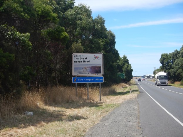
 our first night under canvas for several weeks. It was peak holiday season so we wanted to get a tent site established around midday and only then explore the scenic treasures on the western half of the Great Ocean Road. A short distance took us to the 12 Apostles – above right. There is no doubt that this coastline is magnificent. So
 much so that there is a vast car and coach park inland of the road, with a shiny new building selling tourist essentials such as PEP bottles full of fizz, ice creams and toilets to relieve the masses. A 4 metre wide concrete pathway conveys the incoming tourism tide under the road and over to various look-out points. The human mix was 90% Asian, a bristling mass of ‘selfie sticks’, all looking to demonstrate that they ‘were there’, even if the view of ‘there’ was obliterated by ‘them’. With Tom and Tanys conversations had included reference to quality of life for Aussies and Kiwis as a priority of policy ahead of quantity of GDP growth. Immigration numbers to New Zealand and tourism numbers to both countries were touched upon in the context of a need to start a public debate about having an upper limit. The photo above should serve as a picture of Rotorua, Queenstown, the
 Coromandal, Bay of Islands, Nelson’s Abel Tasman National Park in the future if no cap on inbound tourism is introduced. Unless New Zealand’s policy settings change from GDP growth to growth within the constraints dictated by qualitative factors for Kiwis and visitors to the country, New Zealand is on a trajectory to achieve the sights above at an increasing number of ‘tourism’ sites – it is only a question of how much time.

 The beach for the Tidal river camp site is on the left. The helpful people at the camp site looked after our bike gear leaving us suitably clad to go on a walk to Squeeky Beach (below) and on to Picnic Beach. I boldly ventured into the sea to humiliate some waves with a bit of body surfing. The waves had other ideas and with a couple of glorious exceptions, I experienced the front-loading washing machine treatment.
 and toilet and with no obligation to eat there. We made this our base for three days and ate in the pub every night – excellent value.
 and back to Omeo. On the Saturday (20th) the three of us shifted camp to a little reserve by a bend in the river at Angler’s Rest – photo below
 little river to cool off. That evening it was steak and salad by the river, invigorating conversation and a skyful of stars to bid us all good-night. This is a truly tough lifestyle.
 consigned to lorry transport on 17th and we boarded the 675 metre long Indian Pacific Train at East Perth station for an all-inclusive choo choo ride across to Adelaide, some 2,669 kms to the east.
 Due to a wild storm the previous day, most of the town was in darkness and our trip was confined to a look into the “Superpit”, the largest open cast mine in Australia – also in darkness. The patterns of little lights are the large lorries filling and making their way up and out of the 3.5 kms long, 1.5 wide and 600 metres deep pit. Like the Tom Price mine up in the Pilbara, the numbers were mind-blowing. It took the entire 255 tonnes of dirt in the back of one house-sized lorry, to make a golf-ball-sized lump of gold. The cost of production is high at around US$900 per tonne but with the spot price being relatively stable around US$1200 and the scale of production so vast, there’s a bit of profit being enjoyed.
 with just one train passing through per week, life in Cook might be a fraction dull. But when I asked a chap driving a ute about the pace of life, or something along those lines, he explained how Cook receives visits from other trains, all bringing supplies for the Indian Pacific. Fuel was one example he volunteered. In case you think the railway line shown above looks straight, it was. In fact, 487 kilometres of dead straight rail track – the longest straight stretch of railway in the world.
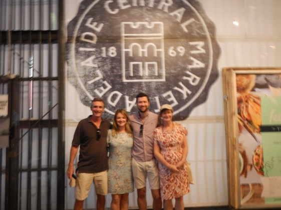
 which, Birthday Boy wished to kick on and find a whisky bar or two. Louise and Holly headed home while I accompanied Hamish as he sniffed out hidden dungeons a little bit like Baxter’s in Sydney. The photo above right was taken in an attempt to record the beautiful manifestations from the top shelf , and as if to back up the claim that the camera never lies, the shot is slightly blurred. After three bars and three delicious shots, I felt it was time to totter home. A great night and a birthday well celebrated.

 get a day’s work in and still see half the action. For us the delayed start facilitated a visit to the Central Markets for a forage and a lunch – right. On his last day we hired a car to visit a few McLaren Vale wineries, starting at D’Arenberg, going out to Yangarra (superb) see photo below

 being to create a predator-proof area in which to experiment with different annual crops, with a small chicken population being rotated to improve soil aeration and nutritional quality.
 into annual crops is to identify a viable diversification to the farm’s main income stream while keeping the manual effort to within the two-person team that is already pushed pretty hard. The photo on the left shows the progress we made relative to the one above it, taken early on in the effort. We enjoyed the work, the learning opportunity and most of all, the insight into this particularly brave and hard-working couple. Thinking of Africa,
  while I was banging in fence posts, Louise spent many hours wrestling a lawnmower over the dry, uneven ground, taking on Kenyan hues as she went – see photo on right of my Kenyan wife.
 I noticed a large Huntsman spider skulking on the map next to me on the bedside table. He didn’t seem to mind being relocated outside as much as I minded him remaining inside.


 Sauvignon was grander than the price suggested.
 sweet backdrop to the flavours arrayed on the pallet. The answer lay beneath our feet in the famous Terra Rossa soils – per the photo of a soil profile to the left.
 wineries we visited or passed had prominent Santas, each demonstrating a particular recreational activity. This ‘theme’ seemed to have been agreed as a local promotion. Louise included a few in her Christmas post. The one above right was outside a farm on the road from Penola back to the flower farm. This one is fishing.
 our time with Jessie and Edna came to an end and on Christmas Day, we took one last glance at the aviary-like theatre and rode off east 340 kms to check into the Mid City Hotel in Ballarat before 12 noon when a ‘Special Christmas Day’ lunch awaited us.

 Wave Rock was the attraction at Hyden. the photo on the right captures not only Wave Rock, but Louise surfing on it.
 original native vegetation for wheat farming has proved short sighted. Relative to what was cleared, cereal crops consume little water and all of that from the surface layer of soil. The lack of water drawn from greater depths by deep rooted plants with greater transpiration rates than wheat, caused the water table to gradually rise. The naturally occurring salt in rain accumulated in the soil with the result that 11% of the land previously in wheat is now too saline for this crop – or any other crop. If no intervention is made, this figure will rise to 30%. Magic Lake was fringed by salt deposits and the other low-lying areas, and as per photo above, are desolate due to the exaggerated salt content. We wish the regional farmers well who are striving to reverse the salt affliction of their own making. Subsequently we crossed the wheat belt on the Perth to Adelaide train, spotting many large low-lying areas where plant life was prohibited by the saline soil. A wave of my wand would see deep wind-powered water bores, solar-powered desalination of that water, then irrigation of it over the salt pans. After a few years, replanting may prove worthwhile followed by a few decades of continued ‘cleansing of the aquafers’ and continued irrigation. Eventually, the dead 11% would be returned to deep-rooted native trees and bush that would prevent the ruination by salinisation from spreading. Easy really.
 The Aboriginal art in the cave was virtually all ‘hands’ with most difficult to discern. We did a marked walk in the area accompanied by squadrons of Aussie flies. The photo on the right shows some hot fashion, complete with a head net.
 had a brief look around, sampled a pie (rated a 5) and departed west. Due to an unsealed road to the intended bush camp being corrugated and covered in something akin to red ball-bearings, we ended up pitching the tent at a road house just short of Ravensthorpe, Esperance itself looked uninspiring but its beaches were sun-drenched white sand and turquoise waters – as above.
 Before describing our more interesting experiences in Albany, take a look at the shot taken from the inside of my motorbike helmet. The insect life in this south west region was prolific with cabbage white butterflies being most obvious, unlike the cabbages that are supposed to attract them. Yet many Harley riders go for the open-faced matt-black helmets – tells you something about Harley riders.


 On the walk up, signs list all of the ships that departed in the 2 convoys with the one on the left listing three of the New Zealand ships.

 The day was a moving mix of enthralling education, inspired interactive displays, real views over King George Sound imagining the sight of the ships awaiting departure and lastly, the magnificent memorial to the horse-born troops, seen only a few weeks after the 100th anniversary of the against-the-odds victory in Palestine.


 Then we visited the Gloucester Tree, one of a handful of ‘look-out’ trees. These are particularly tall Karri Trees that are on forested high ground. Metre long pegs have been banged into them, forming a near vertical spiral ladder allowing observers to scan the surrounding district for bush fires and sound the alarm. Now they serve as tourist attractions, allowing folk to climb up to the top and

 Tree. On the right is a much smaller example of a Karri tree. For Kiwis reading this, there is no relationship between Karri and Kauri, the former being members of the Eucalypt family.
 Darwin, 8,569 since leaving Cairns and 11,669 since beginning this trip in Sydney in mid-May. As we point south at Exmouth, we’re roughly half way along our journey around Australia.
 I had a long wander round while Louise had a rare afternoon sleep. Not really captured on the photo, left, the place was heaving and after our time on the ‘turtle beach’, the crush of humans in Coral Bay was off-putting, repellent even. But the little shopping centre boasted a good bakery where I sampled an excellent beef and mushroom pie. When ‘Er indoors’ emerged we walked to the beach with a swim in mind. However, the cool, strong wind and the undeterred families swarming everywhere persuaded us that a brief paddle was enough


 The visor on my helmet had cracked inexplicably – the temporary fix was fragile – see photo right. HJC, the manufacturer, kindly couriered a replacement visor to a dealer in Geraldton under warranty. Great brand support and service – thank you HJC. Our inflatable mattress, crafted in China, had sprung a leak which saw us getting up in the small hours to puff it up. Not fun in the cold night hours ………. which challenged our summer clothing and bedding to the point that a thick blanket was required to augment the new mattress and encourage more profound sleeps.


 what more can one ask for? Well, two gin and tonics back in the Gingin pub seemed like a good answer.


 short 50 km ride south lay Augusta at the very south west corner of Australia. Just beyond, at the very tip, was Cape Leeuwin with its impressive lighthouse built in 1895.


 back at Conto Camp, the locals were showing what Western Australians do best, just lying back and taking things easy.


 a shot of my thumb in the vicinity of a Whale Shark on my second swim. This graceful fish, and yes, Whale Sharks are fish, was a female moving slowly through the water just below the surface, probably warming up after or before some serious plankton harvesting at cooler depths. At one point I was swimming about 3 metres to her left with no others humans in sight – an unforgettable experience.
 After 200 metres we parked our bikes behind the dunes and walked through to the beach upon which the calm waters of the Ningaloo Marine Park were gently lapping. To anyone watching, it may have seemed as though Mr and Mrs Stig had come to the beach.
 His limbs didn’t seem entirely suited to this endeavour and we saw a few capsizes and premature partings. The sheer effort proved exhausting and the chap below was apparently washed up on the beach. On closer inspection, he was simply buggered from his nuptials and raised his head periodically to draw breath. In a few months, the females were due to climb up the beach and lay their eggs.

 collected from the Kununurra Information centre, thereby allowing us to ride unencumbered the 103 kms to El Questro, not far down the east end of the notorious Gibb River Road. The road was sealed all the way to the turn off into El Questro but we wanted to be much less top heavy and nimble as we tackled the 16 kms of unsealed road in, which included a couple of river crossings. You may recall that we struggled with, and Louise had a couple of spills on, the unsealed road to Gumlon Falls, causing us to abort the visit. Thus it was with a modicum of intrepidation we entered this enormous station, renown globally for its wilderness status and wealth of natural assets.
 comfortably cautious speed. Until we got to the first river crossing. I walked it to gauge “bottom and depth” and then had a go in first gear. The water was about 0.3 metres deep but with the back wheel driving, the bike carved its way across with my legs dangling like a tight-rope walker’s arms. I got quite a buzz from it. Louise had a go but too cautiously, which invited problems, such as the temptation to stop and think about it ………. so we both walked her bike across. Just before reaching the El Questro station and camp site, we had to cross the Pentecost River. This crossing was a bit longer and at one end, a fraction deeper. This time I crossed grinning and whooping like an ape – marvellous fun. Louise wasn’t tempted so I took her bike across as well. But her time was approaching fast.
 we contemplated which of the various thermal pools, gorges and other natural attractions we would tangle with. Virtually all of them required us to go back out along part of the same entrance road, significantly, the part that lay beyond both water crossings. Louise needed no second invitation and across she went without even a wobble. There’s no photo as, by prior agreement, I was standing in the water ready to help!
 both tackling the two water crossings along the way. However, the track off the main drive that led to the Gorge soon became soft sand and both of us struggled with this – see photo on left. We knew that weight as far back as possible (off the front wheel) and a bit of speed was required but neither of us were up to this with unfaded memories of the Gumlon Fall track rushing back, particularly for Louise. We left the bikes at the side of the track (photo above) and walked the couple of kms to the beginning of the walk proper.
 waterfall.

 But then we clambered a little further to a longer, deeper pool with a visible rock at the far end where the waterfall landed…………. doubling as a diving platform. All was shade due to the 100+ metre high gorge walls barely 4 metres apart.


 .
.

 From there we walked to Cathedral Gorge, past or rather through a clearly visible
 fault line that moved 70 metres in one hit when it last bothered. A close look at the photo will show a clear vertical ‘cut’ which is mirrored diagonally across the gorge.
 like most, cannot do this place justice. What a venue for an opera – in the dry season. You can make out where the water drops in – it’s the black tongue to the left of picture
 The temperature was refreshingly cooler. Bushy then whizzed us back to camp by 4.30 allowing Louise and I to forgo the BBQ and ride the 50 kms back up to Turkey Creek before dusk which arrived around 5.15. This had us on full alert as we were approaching sundown when the roos like to bound across the road and wild cattle wander onto it and glare at oncoming traffic. An example of this hazard is shown below.
 Highway, enjoying an overnight bush camp 100 kms beyond Fitzroy Crossing which some people we met at Lake Argyle tipped us off to. Finally, on 15 September, we rode the remaining 290 kms to Broome, leaving the Kimberleys behind us.


 Travellers we had met had raved about this place but for us, the reality was disappointing. The camp site was barren, virtually devoid of shade trees, important in the upper 30s. The ground was hard and red with tent pegs standing no chance. Rob headed off on his Moto Guzzi after just one night.
 We did the full 2 hour walk ending at Fern Pool – shown above.

 On arrival at the Information Centre, I snapped up the chance to go on a tour of the mine leaving 30 minutes later.
 is some of the gear. The Komatsu 830e was the larger of the dump trucks in use. The rear of one and front of another are shown lurking in the garage, more like a hangar, see photo below.
 The figures that poured from our guide’s mouth were mind-boggling. The Komatsu trucks cost A$4.5 million apiece with each tyre a cool A$40,000.

 He bade us meet him at the Darwin Sailing on 31st where the sun and a few beers went down in the outdoor evening warmth that is so comfortable in Darwin – at that time of year. We met up gain at the Saturday morning Parap Markets, grabbed Asian soups and followed him to his partner’s studio. Winsom Jobling is recognised in Australia for her particular form of art ………. which is ‘paper’. She described the process and showed us many examples of here work.

 The US airforce had a major presence in WWII due to it being the RAAF’s most northerly base.
 The B52 sign above didn’t take up much space in the giant hangar but the actual B52 itself
 took up virtually all of it. Gifted the above B52 for display to the public. A massive hangar was erected and today, the Darwin Aeronautical Museum offer the public the opportunity to view several military aircraft from the past, all assembled around and under the gigantic B52.
 the museum visitors are promised nothing less than one of Tommo’s Pies. Having sampled many Aussie pies, I felt I should give this one a go. It didn’t live up to its name!


 The enthusiastic guide told us how the Buffalo grass rises with the water level of the three Alligator Rivers which was low due to The Dry. Large expanses of grazeable land disappear during the wet, allowing the salties to spread out, only to be forced back to their more confined territories in May-June. With his help, we saw: Magpie Geese; Egrets; Night Herons; Cormorants; Willy Wagtails; Crested Pigmy somethings; Whistler Kites; Sacred Kingfishers; Sea Eagles; Red Tailed Black Cockatoos; Sulphur-Crested Cockatoos; Golden Tree Snake and multiple salties.
 We were introduced to “Harry” whose territory we passed through. He was a 5 metre bundle of fun.
 north east corner of the park, past Jabiru (where we posted Sam’s birthday card), in time to pop the tent up at the enjoyably bush Merl camp site before riding the short distance to Ubirr. Here we joined a two hour guided walk up through the craggy rocks that served as a gallery for ancient rock art.
 .
. to and below the horizon. There was something spiritual about this place, it put me in mind of Cape Reinga at the northernmost tip of New Zealand where the Tasman Sea and Pacific Ocean enjoy and enthusiastic meeting.
 Another Dreamtime story, another Spirit Ancestor example, Namarrgon (pronounced narm-arr-gon) is the Lightning Man, an important creation ancestor responsible for the violent lightning storms Kakadu experiences every wet season. We saw drawings of him (left) at the Anbangbang Gallery (think: rock-face-in-a-cave) at Burrunguy (Nourlangie Rock). He uses his stone axes to split the dark clouds and make lightning and thunder. Namarrgon’s story began on the coastline of the Coburg Peninsula and ends in a rock shelter in the sandstone country of the Arnhem Land Plateau – where he remains today. During his travels he left his power behind at many places. On his last journey he approached the escarpment from the east, looked over the sheer wall, then took out an eye and placed it high on the cliff at Namarrgondjahdjam (Lightning Dreaming). Here it sits, waiting for the storm season. This is a sacred and dangerous place that must not be disturbed or catastrophic events will follow. During the build up season you can see Narmarrgon’s children, aljurr (Leichardt’s grasshopper) on the fragrant pityrodia bushes which is the only plant they eat. Then, as every Wet Season begins, Namarrgon, the Lightning Man, asserts himself as great black storm clouds approach from the north, complete with blazing lightning strikes down from the angry skies.